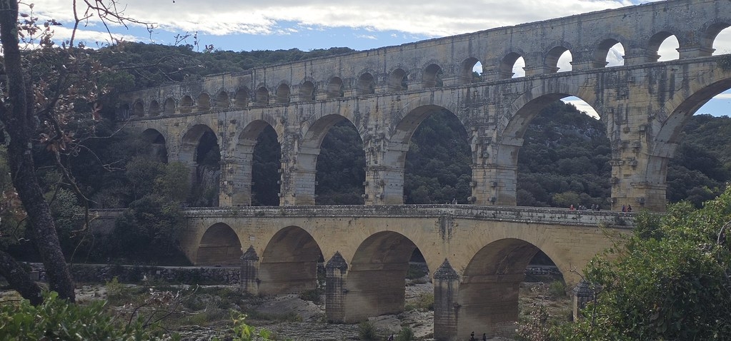
Pont du Gard
Egy elfelejtettnek tűnő völgy, fölötte egy kétszintes római vízvezeték, körülötte fenyő- és olívaerdők, folyó és sziklák. A Pont du Gard nemcsak „láttam–pipálva” UNESCO-helyszín, hanem lassú séta, pancsolás, sziklán napozás és egy kis időutazás is egyben. Ha szereted a nagy ívű történeteket és a lassan csordogáló vizeket, ez a hely nagyon könnyen a szívedhez nő.

Hol van?
Franciaország déli szélén, úgy középtájon, a tengertől ötven kilométerre, Nîmes és Avignon városától húsz kilométerre. Mészkőhegyek között, egy völgyben, amiről az iparosodás megfeledkezett. A völgy felett egy kétszintes viadukt ível át a Gard folyó felett, amit a rómaiak építettek a vízhálózat működtetésére.
Mit fogunk látni?
Fenyő- és olívaerdőket, kirándulóközpontot, sziklákat, hidat, amelyről mintha elfeledkezett volna az erózió.
Hogy került ez oda?
A dél-francia részeken (is), bármelyik faluban állunk meg, biztos, hogy lesz egy római korból ránk maradt emlék. Így, részben kívülállóként, az az érzésem, hogy ezt a területet a rómaiak emelték ki a mocsárból.
Mi a jelentősége manapság?
Igen, római korra utaló nyomokat bárhol találunk úgy kétszázhúsz kilométeres körön belül, de ekkorát sehol sem; főleg ilyen jó állapotút. Ez annak is köszönhető, hogy ezt (is) a későbbi korok is használták. Sőt, a középkorban építettek elé egy másik hidat – pontosabban a meglévőt kiszélesítették az alsó boltívsor magasságában, hogy már ne csak gyalogosan, hanem szekérrel is át lehessen kelni a völgy felett. Ma már a híd egy kilométeres körzete le van zárva – ott vannak a hivatalos parkolók és kempingek. A keresőbe azt érdemes beírni: „musée Pont du Gard”.
Mit ajánl a turista infópont?
A két sorral fentebb megnevezett látogatóközpontot. Látszik, hogy főként családosokra lőnek; nem csupán kiállítótér van itt (ami elmagyarázza a hely keletkezéstörténetét), hanem egy nagy, háromdimenziós bemutatótér, ahol játszani lehet – írja a prospektus:
Én mit néztem meg?
A híd lába alatti szabad strandot, ami nincs elkerítve, sem pedig kiépítve; egyszerűen le kell sétálni a lassú sodrású folyóhoz, kiteríteni egy törölközőt valamelyik hatalmas sziklára, és ezek után már be is lehet sétálni a folyóba – mármint aki bírja az október végi hőmérsékletet. A folyó jobb partján van egy piciny barlang, egy olyan, amiben ősmamáink és őspapáink laktak; azt hiszem, találtak is itt az ősember ittlétére utaló nyomokat. A híd peremén tök jó szelfiket lehet csinálni, ha kicsit behajolunk a boltívek közé. Sőt, ha már ott van az ember, csinálhat látványos panorámafotókat az északi erdőségekről, amit a viadukt kövei kereteznek.
A folyó bal partján, a látogatóközpont feletti hegyen remek túraútvonalak vannak, ahol unalmas mennyiségű római falmaradvány mellett a környék növényvilága is jól átlátható: szőlőskertek, olívafarmok, egykori szénégetők, változatos fák, mezei és erdei virágok. Lehet csinálni harmincperces köröket, de akár félnaposakat is. (Kövessük lépteinket például egy Google Térkép + GPS kombó segítségével, mert a túrajelzések nem egyértelműek.)
Jómagam bringával érkeztem; a nap zárásaként lecsorogtam a folyó bal partján induló kerékpárúton; szinte tekernem sem kellett. Gyönyörű a táj, tényleg olyan, mintha egy romantikus képeslapon sétálgatnánk; lépten-nyomon azt keresi az ember, hogy éppen melyik kis terecske szökőkútjánál vacsorázik Russell Crowe és Marion Cotillard.
Mivel tudnám ezt a programot eladni egy távolról jött, tovarohanó turistának?
A tovarohanás ellentétével!
Manapság bármilyen célpontot el lehet adni, ha odaírjuk áthúzott betűtípussal, félkövéren, hogyturistáshely…
Nos, itt még október végén is van turista bőven, viszont kellően nagy tér áll rendelkezésre ahhoz, hogy kényelmesen kerülgessük egymást. Jöjjön ide mindenki, aki szeret nagyokat sétálni, pancsolni; aki preferálja az olyan helyeket, amelyeket elkerült az urbanizáció.
Én miért jönnék vissza?
Ha több időm lesz, benevezek egy kajaktúrára. Legközelebb nyáron érkezem; kíváncsi vagyok, milyen érzés egy folyó közepén ücsörögni, miközben sok ezer éves emlékek vigyáznak rám.
Nîmes–Pont-du-Gard TGV-állomás, 2025.10.24.

Pont du Gard
An ancient Roman aqueduct striding over a forgotten valley, wrapped in pine and olive trees and a river where you can still wade in at the end of October. Pont du Gard is more than a postcard-perfect UNESCO site: it’s a slow day of walks, rocks, swims and a little time travel. If you like big stories carved in stone and quietly flowing water, this place will win you over fast.
Where is it?
On the southern edge of France, roughly in the middle of the coast, about fifty kilometres from the sea and twenty kilometres from the towns of Nîmes and Avignon. It lies in a valley between limestone hills that industrialisation seems to have forgotten. Spanning the valley is a two-storey viaduct over the River Gardon, built by the Romans to operate the water supply system.
What will we see?
Pine and olive forests, a hiking/visitor area, rocks, and a bridge that erosion seems to have forgotten.
How did it get there?
In southern France, in pretty much any village you stop in, you’re almost guaranteed to find some relic from Roman times. So, as a bit of an outsider, I have the feeling that this whole region was dragged up out of the marshes by the Romans.
What’s its significance nowadays?
Yes, you can find traces of the Roman era almost anywhere within a twenty-kilometre radius, but nothing this big – and especially nothing in such good condition. That’s also because later centuries went on using it. In the Middle Ages they even added another bridge in front of it – or rather, they widened the existing structure at the level of the lower row of arches so that you could cross the valley not only on foot but also with a cart. Today the area within a one-kilometre radius of the bridge is closed off – that’s where the official car parks and campsites are. In a search engine, it’s worth typing “musée Pont du Gard”.
What does the tourist information point recommend?
Exactly the visitor centre mentioned two lines above. You can tell they’re aiming mainly at families: it’s not just an exhibition space (which explains how the site came to be), but also a large, three-dimensional experience zone where you can play; as the official brochure puts it:
What did I go to see?
The wild beach under the foot of the bridge, which is neither fenced off nor built up; you simply walk down to the slow-flowing river, spread your towel on one of the huge rocks, and then you can walk straight into the water – assuming you can handle late-October temperatures. On the right bank of the river there is a tiny cave, the kind our prehistoric grandmothers and grandfathers lived in; I think they really did find traces here of prehistoric humans. On the edge of the bridge you can take great selfies if you lean a little between the arches. And while you’re up there, you can shoot some spectacular panoramic photos of the forests to the north, framed by the stones of the viaduct.
On the left bank of the river, on the hill above the visitor centre, there are excellent hiking trails where, alongside a boringly large number of Roman wall remains, you also get a clear view of the local plant life: vineyards, olive farms, former charcoal burners’ pits, a variety of trees, meadow and woodland flowers. You can do half-hour loops or spend half a day up there. (It’s a good idea to track your steps with a Google Maps + GPS combo, because the trail markings are not very clear.)
I myself arrived by bike; to close the day I simply rolled down the cycle path that starts on the left bank of the river – I hardly had to pedal. The landscape is beautiful; it really feels as if you were walking around in a romantic postcard, and at every little square with a fountain you half expect to see Russell Crowe and Marion Cotillard having dinner.
How would I sell this programme to a tourist who’s come from far away and is rushing onward?
With the exact opposite of rushing. These days you can market any destination if you add, in strikethrough and bold, that it’s a touristy place… Well, here there are plenty of tourists even at the end of October, but there is also plenty of space, so you can comfortably weave around each other. Everyone who loves long walks and paddling should come here – everyone who prefers places that urbanisation has somehow bypassed.
Why would I come back?
If I have more time, I’ll sign up for a kayak trip. Next time I’ll come in summer; I’m curious what it feels like to sit in the middle of a river while several-thousand-year-old memories are watching over you.
Nîmes–Pont-du-Gard TGV station, 24/10/2025
Pont du Gard
Un aqueduc romain qui enjambe une vallée oubliée, entouré de pins, d’oliviers et d’une rivière où l’on peut encore tremper les pieds fin octobre. Le Pont du Gard est plus qu’un site UNESCO de carte postale : c’est une journée lente faite de balades, de rochers, de baignades et d’un peu de voyage dans le temps. Si tu aimes les grandes histoires gravées dans la pierre et l’eau qui coule doucement, cet endroit va vite te rester au cœur.
Où est-ce ?
À l’extrême sud de la France, à peu près au milieu du littoral, à une cinquantaine de kilomètres de la mer et à une vingtaine de kilomètres des villes de Nîmes et d’Avignon. Le site se trouve dans une vallée entre des collines calcaires que l’industrialisation semble avoir oubliées. Au-dessus de la vallée passe un viaduc à deux étages qui enjambe le Gardon, construit par les Romains pour alimenter le réseau d’eau.
Qu’est-ce qu’on va voir ?
Des forêts de pins et d’oliviers, une zone de randonnée et de loisirs, des rochers, et un pont sur lequel l’érosion semble avoir oublié de faire son travail.
Comment ce pont est-il arrivé là ?
Dans le sud de la France, dans n’importe quel village où l’on s’arrête, on a de grandes chances de tomber sur un vestige de l’époque romaine. Du coup, en tant que quasi étrangère, j’ai un peu l’impression que cette région a été littéralement sortie des marais par les Romains.
Quelle est son importance aujourd’hui ?
Oui, on peut trouver des traces de l’époque romaine un peu partout dans un rayon d’une vingtaine de kilomètres, mais rien d’aussi grand – et surtout pas dans un état de conservation aussi impressionnant. Cela tient aussi au fait que les siècles suivants l’ont, eux aussi, utilisé. Au Moyen Âge, on a même construit un autre pont par-dessus – ou, plus exactement, on a élargi la structure existante au niveau de la rangée d’arches inférieure pour qu’on puisse traverser la vallée non seulement à pied, mais aussi en charrette. Aujourd’hui, un périmètre d’un kilomètre autour du pont est fermé à la circulation – c’est là que se trouvent les parkings officiels et les campings. Dans un moteur de recherche, le plus simple est de taper « musée Pont du Gard ».
Que propose l’office de tourisme ?
Précisément le centre de visiteurs mentionné deux lignes plus haut. On voit bien qu’ils visent surtout les familles : il n’y a pas seulement un espace d’exposition (qui explique l’histoire du site), mais aussi un grand espace de découverte en trois dimensions, où l’on peut jouer ; comme le dit la brochure officielle :
Qu’est-ce que moi, j’ai visité ?
La plage sauvage sous le pied du pont, qui n’est ni clôturée ni aménagée ; il suffit de descendre jusqu’à la rivière au courant lent, d’étendre sa serviette sur l’un des gros rochers, et on peut déjà entrer dans l’eau – du moins pour ceux qui supportent les températures de fin octobre. Sur la rive droite se trouve une toute petite grotte, du genre où vivaient nos arrière-grands-mères et arrière-grands-pères préhistoriques ; je crois qu’on a effectivement trouvé ici des traces de la présence de l’homme préhistorique. Sur le bord du pont, on peut faire de super selfies si l’on se penche un peu entre les arches. Et tant qu’on y est, on peut aussi prendre de spectaculaires photos panoramiques des forêts au nord, encadrées par les pierres du viaduc.
Sur la rive gauche, sur la colline au-dessus du centre de visiteurs, il y a de très beaux sentiers de randonnée où, en plus d’une quantité presque ennuyeuse de vestiges de murs romains, on peut bien observer la végétation de la région : vignes, oliveraies, anciens fours à charbon de bois, arbres variés, fleurs des champs et des bois. On peut faire des boucles d’une demi-heure, ou bien y passer une demi-journée. (Mieux vaut suivre ses pas avec un combo Google Maps + GPS, car le balisage des sentiers n’est pas très clair.)
Moi, je suis arrivé à vélo ; pour clore la journée, je me suis laissé porter sur la piste cyclable qui part de la rive gauche, presque sans pédaler. Le paysage est magnifique, on a vraiment l’impression de se promener dans une carte postale romantique, et à chaque petite place avec sa fontaine, on se surprend à chercher du regard à quelle table de terrasse dînent Russell Crowe et Marion Cotillard.
Comment je vendrais ce programme à un touriste pressé venu de loin ?
Avec l’exact contraire de la précipitation ! De nos jours, on peut vendre n’importe quelle destination en ajoutant en lettres barrées et en gras que c’est un endroit touristique… Ici, il y a encore beaucoup de visiteurs fin octobre, mais l’espace est suffisamment vaste pour qu’on puisse se croiser sans se gêner. Que tous ceux qui aiment les longues balades et la baignade viennent ici, tous ceux qui préfèrent les endroits que l’urbanisation a plus ou moins laissés de côté.
Pourquoi, moi, je reviendrais ?
Si j’ai plus de temps, je m’inscrirai à une sortie en kayak. La prochaine fois, je viendrai en été ; je suis curieux de savoir ce que ça fait de rester assis au milieu d’une rivière pendant que des souvenirs vieux de plusieurs millénaires veillent sur moi.
Gare TGV Nîmes–Pont-du-Gard, 24.10.2025.

Avignoni hangulatok


